Click the images for enlarged view |
| Location |
Wagener Glen is a tributary
of Keuka Lake near the town of Pulteney in Steuben
County. It's a little less than 5 miles south of Branchport.
|
| Access
Map
|
Private
Access
from the bottom from Route 54A and from the top
from County Rd. 78 (Pulteney-Browns Corners Rd.).
|
| Hiking |
Moderate to difficult.
We hiked from the bottom up to the main falls, and
then above the main falls to the second falls where
we were stymied by a deep pool, sheer cliffs, and
rotten ice on the one possible route up steep shale
ledges. We then hiked from County Rd. 78 down until
we came to the top of the third (?) falls. |
| Details |
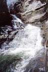
The hike from the bottom
is up a pretty stream bed with lots of flat ledges
reaching the base of the main falls after about 1/2
mile. The main waterfall is an impressive fifty foot
cascade flowing out of a narrow slot in the 200' high
shale cliffs.We scrambled up the left side on shale
dust scree to a narrow and exposed ledge leading to
the top of the falls. We were then in a narrow and
imposing corridor between 100' cliffs leading a short
distance to the second falls, about 22' high. The
ice completely covered the ledges on the right side
so we don't know if we could have proceeded during
the summertime.
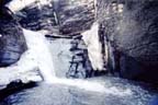
The hike from the top down started upstream from
the bridge with a steep scramble down to the stream
bed. Then we climbed down a series of ledges and
4' to 6' waterfalls to the crest of a 30' waterfall
with sheer cliffs on both sides. From that vantage
point, we could not positively state that there
were no falls between #2 and #3. There is an impressive
view of the glen from the cemetery on County Rd.
78. |
|