|
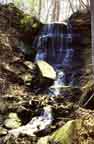
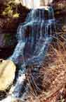
There are two waterfalls here. To visit Turning Point South, follow
the bike path south from the parking lot for about 250 yards. Look
for a path to the left down through the bushes to a dirt path which
is parallel to the bike path and about 20 feet lower. You can see
the waterfall from this dirt path.
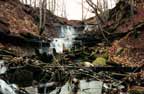
To visit Turning Point North, follow a utility road north from
the parking lot. Where the river widens to form the Turning Point
Basin, follow a trail to the left and follow the rim of the cliff
above the river until you get to the waterfall, about 1/4 mile.
Both waterfalls are about 30 feet high and both, unfortunately,
are littered with trash.
Thanks to "Scottm" for the following:
I am an outdoor person who grew
up in the Boxart Street area as a kid. Now I spend
my time in the High Peaks area, but I go down
to Turning Point on the weekends to walk, exersize
the dog, and some occasional Summertime night
fishing for 'cats'. For as long as I remember,
and from what the previous generations told us,
the 'North' falls were always called "Brown Falls",
for the brown bedrock, and the southern falls
were obviously "Red Falls" for the red clay bedrock
they tumble over. I just met a woman who grew
up there as a kid back in the 40's and she' knew
them both as Brown and Red Falls.
And to Richard Waterhouse for:
The north falls is Red Falls, the south is Brown
Falls.
And to "anonymous" for:
... regarding Turning Point
Park I think ScottM is correct. The notes contradict
each other. I've head the south falls referred
to as Red Rock Falls or Bullock's Falls. I
don't know the name of the north falls.
|