| Hiking |
Easy walk
in the woods from the Johnson Hill Rd. parking lot
to the crest of Upper County Line Falls (about 2/3
mile round trip). If you do the full hike described
below (2 miles, 1 hour), there is a short steep section
going down to Reynolds Gull which is of medium difficulty.
For
an ambitious hike (plan 2-3 hours), you could combine
the County Line Falls hike with a trip up Reynolds
Gull to see the three waterfalls in this larger
stream.
|
| Details |
We visited
County Line Falls on a beautiful Fall day with color
in the Hemlock hills at its peak. From the parking
lot on Johnson Hill Rd., it is an easy walk on an
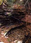
old logging road to the crest of Upper County Line
Falls (35'), which is in a beautiful hemlock glen.
From the crest, we could just see the crest of Lower
County Line Falls about 200 feet downstream. If you
were determined and had a rope, you could probably
get to the base of the Upper falls and then walk in
the stream to the crest of the Lower Falls (but we
did not try this).
We continued on the trail on the south side of
the stream for another 1/4 mile until we came to
a steep hill leading down into Reynolds Gull. At
this point, the logging road took a sharp left to
go up the hill. We found a small, somewhat indistinct
trail which led down the hill to the right (west).
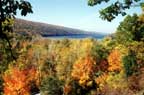
Within 150' or so, we came to a cliff overlooking
route 15A with a wonderful view up the length of
Hemlock Lake and across the wetlands at the head
of Hemlock Lake. We then scrambled down the hill
to the left of the cliff into Reynolds Gull (this
part is about 150' long and is the only moderately
difficult part of the hike). Once down, we crossed
the stream and climbed up to the parking lot at
the base of Reynolds Gull. From there, we walked
north on the shoulder of Route 15A and in less than
1/4 mile came to the the gully where the County
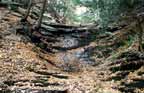
Line Stream goes under the highway. The base of
Lower County Line Falls (25') is less than 100 yards
from the highway. (With determination, you could
probably scramble up the left side of this waterfall
and gain access to the base of the Upper falls,
but we did not try it.) We then continued up Route
15A and returned to our car at the Johnson Hill
Rd. parking lot.
We've driven by this gully hundreds of times and
never noticed it. Thanks to Mike and Hazel for pointing
it out to us |