|
Today I scouted Little Mill Creek between Lower Whiteman falls and route 63. Starting at route 63 and working upstream,
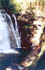
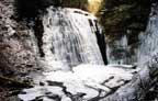
I found a 3 ft falls along with the remnants of an old dam. Farther upstream I found a 10 ft falls with a 10 ft dam above it.
There was no easy route around the falls and dam and I was alone so I turned around.
There is a 10 inch water pipe (now empty) coming from this dam that follows the creek.
Starting from Whiteman Gull road I started downstream. I went through the tunnel under the RR embankment.
I was glad I had a flashlight. There is some thigh deep water near the downstream end of the tunnel.
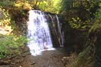
I found another falls about 5 ft high. I didn't get quite as far as the pond above the dam that I had found before,
but I think I was close. I tried to find another route out. There was an improved path that led up the bank,
but it washed out in a side valley. From the age of the trees that have grown up in it,
I'm guessing it may have provided access during construction of the RR embankment. I returned throught the tunnel.
I'll send pictures when (if) I get them back. (The loose film in my pocket got wet.) |