|
|
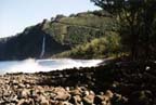
Waipi'o Valley - Hawaii |
Click the images for enlarged view
|
|
||
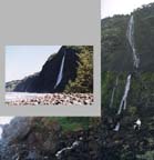
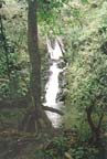
Nanaue Falls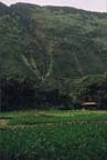
 Papala Falls 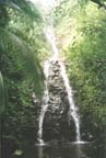 |
The trail along the back of the valley is not so great -- it's poorly marked and maintained and wanders around through thick jungle to avoid private land. We got the distinct feeling that hikers on this trail are tolerated, but not welcomed. |
||
Hiilawe Falls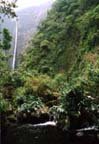
  View from Teahouse 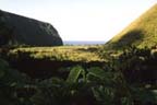 |
The valley
gets wilder as you go further back in but even though we
were more than two miles from the beach, we were still below
the 20' contour line. You can imagine what a 100' high Tsunami
would do (and it has done it repeatedly throughout history).
We gradually worked our way out from the cliff onto a network
of jeep trails which eventually crosses the multiple stream
channels and connects to the county "road" on
the east side of the valley. Then, the climb back up to
the Waipi'o Overlook and our rental feeling somewhat superior
to the tourists riding up in the many 4WD jitneys doing
business there.
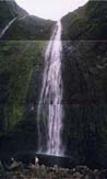
The prize hike was to Hiilawe Falls, actually two hikes. The first was up the stream to the base of the falls, a demanding hike and much longer than it looks since your sense of scale is somewhat twisted. The main part of Hiilawe Falls is 1,300' and we estimate that there is an initial drop of 150 feet above that. The second hike was to the abandoned, very surrealistic "Tea House" with its formal gardens almost totally reclaimed by the jungle. It's about 1/4 mile from the base of the falls with a commanding view of the falls on one side and the Waipi'o Valley and ocean on the other. Evidently it was a millionaire's folly left to rot when it turned out that his wife wouldn't even stay there the first night. (This happened about 20 years ago although the locals were somewhat vague about its history.) Both of these hikes are on private land and we understand that hikers are strongly discouraged unless you hire a local guide. We couldn't find either a guide or anyone to ask permission... nor did we encounter anyone on either hike. |
View from "Z-trail"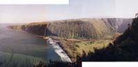
Following image courtesy of Scott Rowland and NASA's Virtually Hawaii project, borrowed with permission. 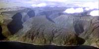 |
Awesome as it is, we couldn't
help contrasting the Waipi'o Valley's waterfalls with our approachable
and friendly Finger Lakes waterfalls. It is amazing to us that Hiilawe
Falls, which has to be one of the highest waterfalls in the United States
(and double the height of Akaka Falls which
is dubbed the highest waterfall in Hawaii), is so unknown and inaccessible
even though hundreds of tourists visit to within one mile of it every
day.
|
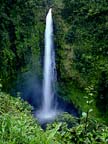
Akaka Falls |
|
UPDATE: From Sally
Williams, Mar 26, 06

|
|||
![]()
![]()
![]()
![]()
![]()
Send mail to feedback
with questions or comments about this web site.
Copyright © 1998 -
2006, Ruth's Waterfalls of the Finger Lakes, Rochester,
and Ithaca, NY, All
rights reserved
Content date:
Last modified: 28-Mar-2007