Upper Calf Creek Falls - Utah

Home
Waterfalls
Contents
What's New


calf2.jpg (14884 bytes)

calf1.jpg (16580 bytes)

Lower Calf Creek Falls
calfcreek.jpg (18874 bytes)

Click the images for enlarged views

Location Southwestern Utah
Access National Forest. There is a parking lot and trailhead at the end of a short (100 yards) very bumpy road off Route 12, 5.5 miles south of the intersection of Route 12 and the Burr Trail in Boulder. There's no sign on the highway but there is a registration box at the trailhead.
Hiking Not difficult, but quite strenuous. Hike down a steep slickrock slope following cairns. The trail levels somewhat as you approach the canyon. Look for a fork as you near the falls with the right fork going to the top of the falls and the left fork to the base. Round trip is about 2 miles. The vertical distance is about 800'.
Details

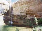
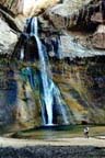
This is one of the prettiest "desert oasis" waterfalls we've seen with an 87 foot waterfall dropping into a large pool on what is described as a perennial stream. Lush green hanging gardens and vivid yellow, orange and red rock formations enhance the setting.
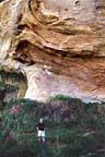
A short distance from the falls is a huge overhang forming a cave with a pool in the bottom. When we were there (mid morning) the sun was reflecting from the pool onto the ceiling of the cave. We didn't try to reach the pool because of virtually impenetrable vegetation and deep mud. However, two ducks were good enough to make ripples in the water creating a fantastic light show on the ceiling.

Best time for photography is not morning since the falls are in half shadow. Wait until mid-afternoon or for a cloudy day.